Digital Twin Project
Gerald R. Ford
International Airport Runway
Gerald R. Ford International Airport Authority | Grand Rapids, Michigan, USA
The Gerald R. Ford International Airport (GRR) is one of Michigan’s busiest aviation hubs, serving millions of passengers annually and supporting regional economic growth. Its runways are critical assets, requiring monitoring and proactive maintenance to ensure operational safety and efficiency.
The Challenge
In 2025, GRR demonstrated a need for a more comprehensive assessment of the pavement that acquires 100% of the pavement surface without operational disruption. Traditional PCI inspections and pavement surveys often capture only about 20% of the total surface area and are challenging to conduct in high-traffic zones such as active runways and taxiways. This can result in partial datasets, leading to inaccuracies in maintenance planning, an inability to precisely detect areas of changing pavement, and inaccuracies in pavement lifecycle cost estimates.
The lack of complete coverage in an area is particularly important, as deterioration can often be localized on an airfield surface. For example, drainage issues, uneven loads, and variability in construction material or workmanship can all create localized deterioration. In addition, the location, amount, and type of deterioration can dramatically impact the type of repair or rehabilitation needed for the asset.
For example, while both low severity longitudinal cracking and alligator cracking are both different forms of cracking, they result in different types of repair methods. Low severity longitudinal cracking generally can be resolved with a sealant or apoxy, to prevent moisture infiltration and foreign object debris (FOD) risks, whereas alligator cracking generally indicates structural failure, requiring reconstruction of the affected area.
As a result, if deterioration on the pavement surface is only captured from a small portion of the pavement, information about repair needs and quantities, which can impact airport owners and their contractors.
Timeline
September to November 2025
Technologies Used
- AUTOSPEX® – AI-powered distress detection, quantification, and change tracking.
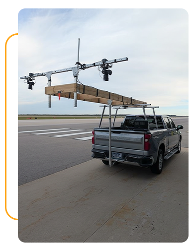
- DRONIC® – Vehicle-mounted high-resolution optical data capture system.
Execution
- Conducted 100% optical capture of Runway 08R/26L during low-traffic nighttime periods using a vehicle-mounted imaging system.
- Collected overlapping, high-resolution imagery with artificial lighting for full surface coverage.
- Processed imagery into a 3D digital twin (1 to 3 mm resolution).
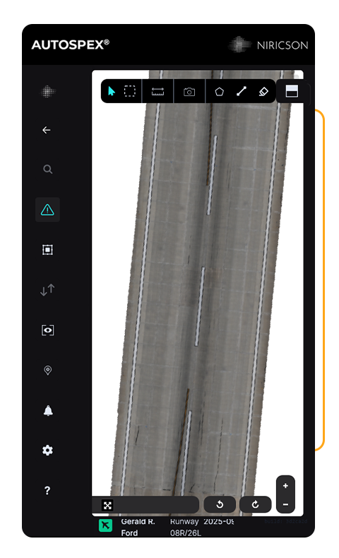
- Generated 2D orthophotos (1 to 3 mm resolution) and applied AI/ML inferences to detect and quantify distresses including cracking, spalling, and surface wear.
- Performed QA/QC review of AI-generated defect maps to ensure accuracy, cross-compared against a traditional PCI engineering consultant pavement inspection.
- Delivered final results in the web-based AUTOSPEX® platform and provided airport staff onboarding for long-term use.
Data Collected
Optical imagery (high-resolution digital capture).
Workflow
- Data Capture
- Geospatial Processing (3D and 2D models)
- On-site Quality Control to Ensure Full Coverage
- AI Distress Detection and Quantification
- Defect Map QC
- AUTOSPEX® Web-based Onboarding
Results and Impact
Key Outcomes
As a result of the survey, Niricson produced 2D and 3D defect maps, mapped out pavement distresses, and provided a report and access to the generated data via AUTOSPEX®. Niricson’s photogrammetric distress mapping was reviewed by a licensed pavement engineering consultant in a side-by-side comparison of the traditional pavement inspection method versus the photogrammetric pavement inspection method.
The data was integrated into a GRR Pavement Management System (PMS) by exporting detected distress data—including cracks, spalls, and raveling—as spatially referenced datasets (for example, CSV files) that include defect type, quantity, severity, and location. These defect datasets were aligned with the PMS pavement section boundaries through a GIS layer to ensure each defect corresponds to the correct management section. The Niricson defect classifications were then translated into standard ASTM D5340 distress types, severities, and quantities so they can be read by systems such as MicroPAVER or APMS and converted into Pavement Condition Index (PCI) values. GRR integrated the exported PCI values into their long-term pavement planning and uses AUTOSPEX® to verify defect-specific information at exact locations.
A summary of key achievements is provided below:
- Achieved full runway coverage without the need for extensive closures. Delivered a complete digital representation of the pavement surface with a 3D digital twin and 2D distress maps hosted on the AUTOSPEX® cloud platform, enabling in-office analysis.
- Provided an exportable Excel database of distresses categorized by type, size, location, and severity for PCI calculation and maintenance estimates.
- Enhanced repeatability compared to traditional PCI methods. Based on GRR’s review of the data and budgetary capacity, GRR may initiate a maintenance or rehabilitation design program where Niricson’s distress maps can be overlaid on AutoCAD 2D engineering drawings. This accelerates drafting workflows and reduces cost-overrun risk by providing precise defect quantities.


